Have you ever imagined what your city looks like from above? The “Daily Summary” program is the best way to appreciate these images through aerial or satellite photographs, in which you can observe different points of our planet, as well as the architecture and designs of buildings, houses, bridges. They will leave you impressed.
Table of Contents
SEE ALSO:
- 16 Coincidences That Could Only Happen ONE in A MILLION
- Six Mysterious Books That Hold Big Secrets
- 20 Most Stunning Images You’ll See in Your Life and Yes, They’re Real!
1. Newark-Elizabeth Marina Terminal Parking Lot, in New Jersey, USA
2. Amazon Rainforest, Brazil
3. Artificial Island, Dubai
4. Greenhouses in Almeria, Spain
5. Vineyards, Huelva, Spain
6. Venice, Italy
7. Residential area in Killen, Texas, USA
8. New Bullards Bar Reservoir, Yuba County, California
9. Desert Shores Community, Las Vegas, Nevada
10. The Great Wall of China
11. Central Park, New York, USA
12. Airport in Tucson, Arizona, USA
13. Barcelona, Spain
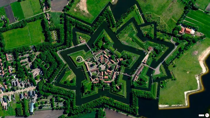
14. Bourtange, Vlagtwedde, Netherlands
15. Irrigation Site for Central Pivot Irrigation’s Fields, Saudi Arabia
16. Edson, Kansas, USA
17. Tree Deforestation Zone in Georgetown, USA
18. Rice Terraces, Yunnan, China
19. Brønby Municipality, Copenhagen, Denmark
20. Agricultural Development, Loxahatchee, USA
21. Vialidad Spaghetti Junction (A-3 and M-50), Madrid, Spain
22. Imman Yard, Georgia, USA
23. Palm Island, Florida, USA
24. Nuestra Señora de la Almudena Cemetery, Madrid, Spain
25. Agricultural Development in Addis Ababa, Ethiopia
26. Vallescas Bridge, Madrid, Spain
27. Port of Los Angeles, California, USA
28. Venture Out RV Resort, Arizona, USA
29. Boca Raton, Florida, USA
30. Gibraltar International Airport
31. Amsterdam, Netherlands
32. Alexandria, Egypt
33. O’Hare International Airport, Chicago, USA
34. Brasilia, Brazil
35. Canberra, Australia
Related:
Comments