The wonderful images that we can find in Google Earth come from various sources, from satellites in geostationary orbit that splice low-resolution photographs taken tens of thousands of kilometers above the Earth, from satellites closer to the surface that capture higher resolution photographs, and even from aerial photographs taken by comets. planes, drones, and even hot air balloons.
The images are available to anyone who accesses their map service online and more specifically to those who download the software. From a mysterious spiral in the Egyptian desert to supposed secret bases and ghost islands in the South Pacific, today we present some strange wonders that we know thanks to Google Earth.
SEE ALSO:
- Exploring the World from Above: Photos from Drone Photo Awards 2023
- Places on Earth that seem to be from another planet
A UFO in Australia?
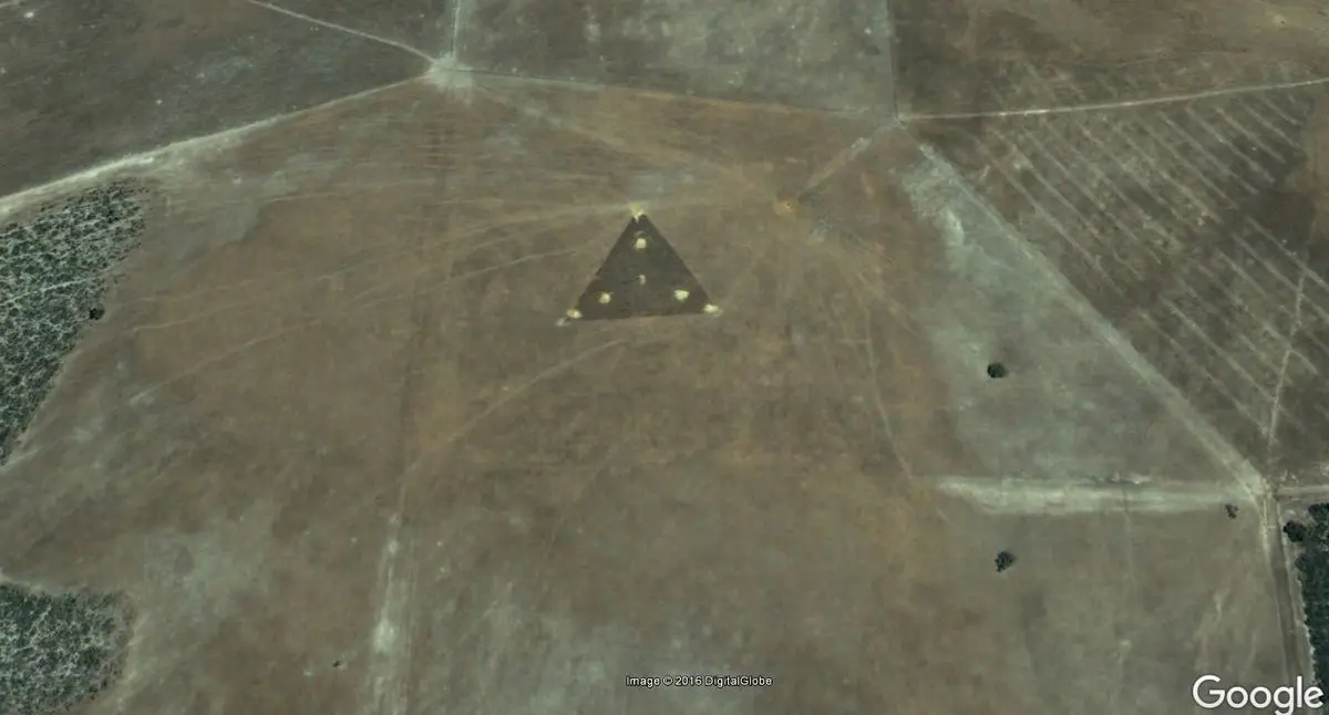
At coordinates 30°30’38.44″S 115°22’56.03″E over Australia, it was possible to see a strange dotted triangle with bright lights in the center that the satellite captured in 2004. When it was first discovered in 2007, ufologists were quick to dub it the “UFO triangle” and claimed it had been caught floating over the Earth.
Other Google Earth users said it may have been an antenna related to a nearby wind farm that was remotely controlled. With three wires forming a triangle and a central tower, the antenna probably received and transmitted control signals.
Nowadays the triangle no longer exists and in its place it is possible to see a wind generator.
The lips of earth.
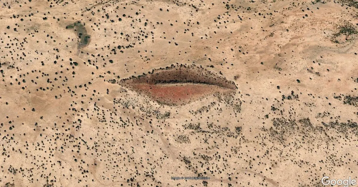
What appears to be full lips is actually a geological irregularity located in West Darfur, Sudan. It can be seen at coordinates 12°22’13.32″N, 23°19’20.18″E.
The satellite image that captured these lips dates back to 2005, in the 2013 images the “lips” almost disappear.
A great shipwreck.
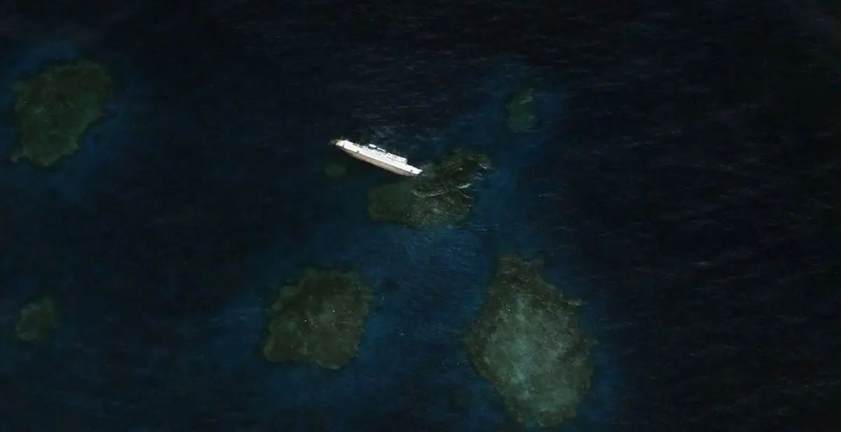
A Bolivian-flagged cargo ferry named SS Jassim ran aground and capsized in the Wingate Coral off the coast of Sudan in 2003. At 81 meters long, this is one of the largest and most visible shipwrecks on Google Earth, it is located at 19° 38′ 46.00″ N, 37° 17′ 42.00″ E.
Currently from the surface it is only possible to see a fragment of the bow of the ship that has been progressively swallowed by the ocean.
The puzzles of the Gobi Desert.
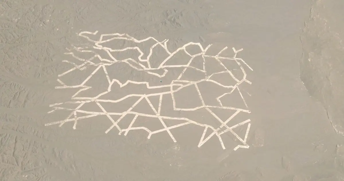
A series of images recently discovered through Google Earth show strange patterns and structures etched onto the surface of the Gobi Desert in China. According to some experts, it would be a secret military base, and the structures would be used for a variety of purposes, including weapons testing, spy satellite calibration, and radar instrument testing.
The most elaborate pattern, an intricate grid of straight lines that weave back and forth every few hundred feet across 33 kilometers, resembles a network of Yagi antennas, used for weather monitoring and other atmospheric research.
The points of interest are:
40°27’31.2″N 93°18’47.3″E
40°24’49.6″N 93°35’01.5″E
+44° 45′ 11.05″, +93° 30′ 7.84″
40°27’07.6″N 93°44’31.6″E
An extraterrestrial base?
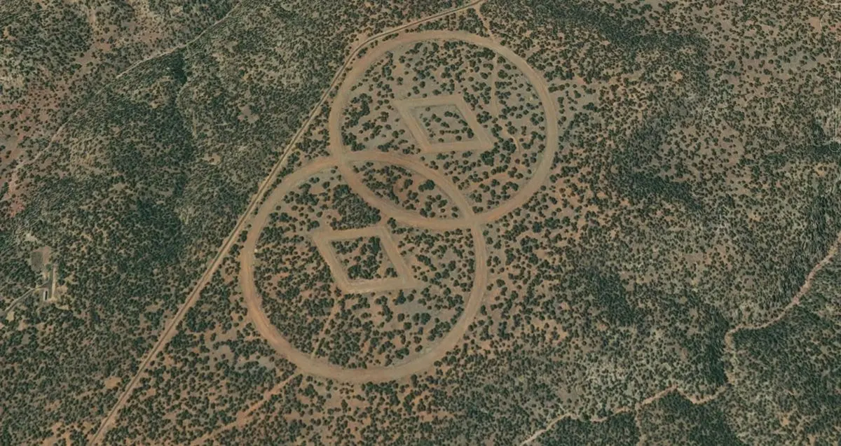
Engraved in the vicinity of the desert near Mesa Huerfanita, New Mexico, it is possible to find a pair of rhombuses surrounded by overlapping circles. An author named John Sweeney claimed that it is a secret bunker owned by the Church of Scientology.
Why these symbols? According to the theory, these drawings on the desert floor would serve as a guide for Scientologists who would return to Earth after escaping an “Armageddon.” Obviously this is unlikely, but the symbols still remain a mystery.
It is possible to find them already deteriorated at 35.524425° -104.571639°
Wild elephants.
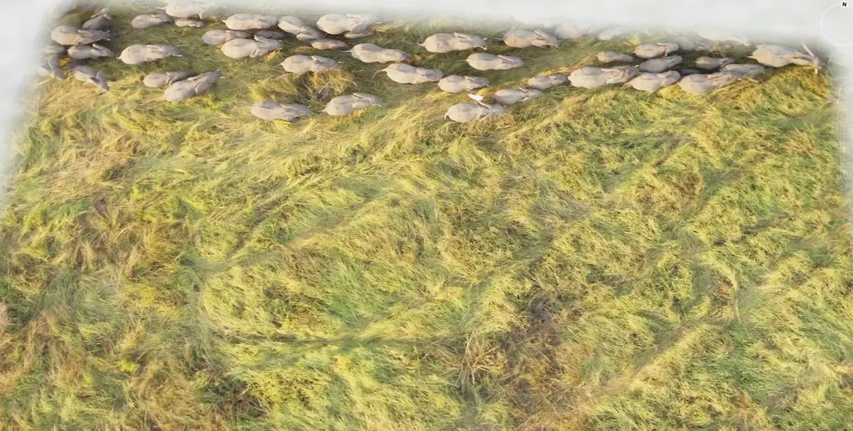
Many of us may never get the chance to see African elephants in their natural state, but luckily satellites have high-resolution snapshots of these giant mammals herding across the Chadian savannah. You can see three photographs at coordinates 10.903497 N,19.93229 E.
A big name.
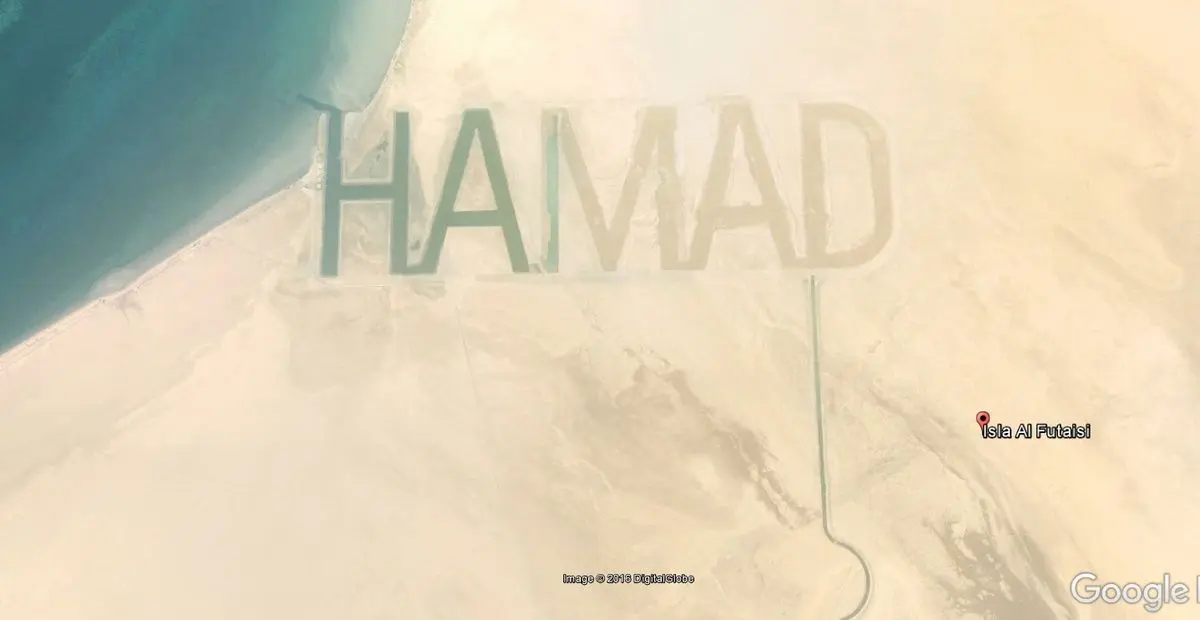
Remember that teenage mania for putting your name on any surface? Well, a millionaire sheikh named Hamad Bin Hamdan Al Nahyan, a member of Abu Dhabi’s ruling family, decided it was a good idea to take that mania to the extreme by drawing his first name on Futaisi Island, which is part of the Persian Gulf.
At 800 meters high and 3.2 km long, the letters of “HAMAD” are perhaps the largest ever created by mankind. Regardless, they were visible from space. Usually the words written on the sand are swept away by the waves, but these were large enough to form watercourses that absorb the power of the tide. At the time the images were taken, it is possible to see that the water reaches the letter M.
But unfortunately the name did not withstand the inclement weather and in the current images it can be seen completely erased. You can find them at 24.345867° 54.323594°
A spiral in the desert.
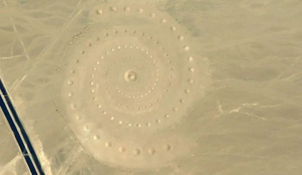
Is it a portal to an alternate Universe? Maybe an extraterrestrial message? Or an ancient monument? This gigantic spiral traced in the Egyptian desert, near the shores of the Red Sea, is actually a work of art called Desert Breath.
In March 1997 Danae Stratou, Alexandra Stratou and Stella Constantinides crafted this 100,000-square-meter piece of art to commemorate “the desert as a state of mind, a landscape for the mind.”
The truth is that it is much prettier from the surface. You can find it at 27.380256° 33.632272°
The Ghost Island.

In 2012, a group of Australian researchers pointed to an “undiscovered” island the size of Manhattan in the South Pacific. A mysterious place called Sandy Island appears on maps in the northwest of New Caledonia. Even Google Earth delimits it with a polygon. But scientists sailing in 2012 found nothing but water instead of dry land.
In a paper about the island published in 2013, researchers explained why a ghost land had been included on maps for more than a century, pointing out some human error and a pile of pumice.

Comments